We welcome you to the official site of the Research Station of the Russian Academy of Sciences in Bishkek city.
Federal State Budget Institution of Science Research Station of the Russian Academy of Sciences in Bishkek city is the research organization subordinated to the Ministry of Science and Higher Education of the Russia Federation.
The Research Station of RAS engages 57 scientific workers, including 26 researchers, 2 Doctors of Sciences and 8 Candidates of Sciences among them. The overall staff amounts 133 employees.

Address
![]()
720049, Kyrgyzstan.
Bishkek-49, Research Station RAS.
Phone: +996 (312) 613-140
Fax: +996 (312) 611-459
Director

Anatoly Kuzmich Rybin
Doctor of Science
in Physics and Mathematics
e-mail: rybin@gdirc.ru
Symposium (publication in IOP)
Thursday, 09 September 2021 14:12


Dear participant of the Symposium!
Earlier, the Organizing Committee of the VIII International Symposium "PROBLEMS OF GEODYNAMICS AND GEOECOLOGY OF INTRACONTINENTAL OROGENES" (June 28 - July 2, 2021, RAS Scientific Station, Bishkek, Kyrgyzstan) invited you to publish your paper presented at the Symposium in a foreign publication site «IOP Conference Series: Earth and Environmental Science».
Please note that due to technical reasons the bank details of the Research Station have changed. Please use the updated details when filling out the contract (the template of the contract with an individual with corrected bank data is attached to the letter - only clause 8 of the contract has been changed).
Please note that to publish your paper in the IOP Conference Series: Earth and Environmental Science, you need to send the following package of documents to the Organizing Committee:
- Article in doc-file format in two copies (duplicate in Russian and English), designed using templates and in accordance with the requirements of the publication «IOP Conference Series: Earth and Environmental Science»: https://publishingsupport.iopscience.iop.org/questions/preparing-your-proceedings-paper/ https://publishingsupport.iopscience.iop.org/questions/templates-and-guidelines-for-proceedings-papers/
Allowed volume of article is 5-8 pages, including figures and tables.
- A scanned copy of your organization's expert opinion on the possibility of publishing article materials in the open press in the IOP Conference Series: Earth and Environmental Science according to the form accepted in your organization.
- A scanned copy of the contract (either signed by the responsible author of the article(s), if you will personally pay for publication services, or by the director of your organization, if payment through an organization is expected - contract templates are attached).
Documents should be sent to This e-mail address is being protected from spambots. You need JavaScript enabled to view it by September 15, 2021.
More information about the conditions and terms of publication is in the attached files.
All the best!
Last Updated on Friday, 10 September 2021 10:09
The article of the research team was published in the international scientific publication of the first quartile
Thursday, 02 September 2021 13:06
A scientific article in English "NOCFASS: Quantitative description of the seismic noise-like signals in the earthquake-prone areas" by the team of authors was published in the journal in the top-rated scientific journal of the first quartile Measurement: Journal of the International Measurement Confederation published by Elsevier.
The article was prepared by authors from various organizations: Nigmatullin R.R. (Kazan National Research Technical University named by A.N. Tupolev-KAI), Rybin A.K. (Research Station of the Russian Academy of Sciences in Bishkek), Nepeina K.S. (Research Station of the Russian Academy of Sciences in Bishkek) and P.A. Kaznacheev (Schmidt Institute of Physics of the Earth).
More information can be found here: The article of the research team was published in the international scientific publication of the first quartile.docx
Absolutely everyone can download the article (until October 12, 2021) by following the link: https://authors.elsevier.com/a/1ddPexsQaEgL5
Last Updated on Thursday, 02 September 2021 13:15
RS RAS, Bishkek - Symposium (publication in IOP)
Wednesday, 11 August 2021 10:27
Dear participants of the Symposium!
The Organizing Committee of the VIII International Symposium "PROBLEMS OF GEODYNAMICS AND GEOECOLOGY OF INTRACONTINENTAL OROGENES" (June 28 - July 2, 2021, RAS Scientific Station, Bishkek, Kyrgyzstan) invites you to publish your paper presented at the Symposium in a foreign publication site
In case of your consent you need to send to the Organizing Committee the following package of documents:
- Article in doc-file format in two copies (duplicate in Russian and English), designed using templates and in accordance with the requirements of the publication «IOP Conference Series: Earth and Environmental Science»: https://publishingsupport.iopscience.iop.org/questions/preparing-your-proceedings-paper/ https://publishingsupport.iopscience.iop.org/questions/templates-and-guidelines-for-proceedings-papers/ . The allowed article size is 5-8 pages, including figures and tables.
- A scanned copy of your organization's expert opinion on the possibility of publishing article materials in the open press in the collection «IOP Conference Series: Earth and Environmental Science» in the form adopted in your organizatoin.
- A scanned copy of the contract signed by the responsible author of the article (a template is attached).
Documents should be sent to This e-mail address is being protected from spambots. You need JavaScript enabled to view it by September 15, 2021. More detailed information about the conditions and terms of publication is reflected in the attached agreement.
Good luck!
Olga Borisovna Zabinyakova
Academic Secretary of Research Station of the Russian Academy of Sciences in Bishkek This e-mail address is being protected from spambots. You need JavaScript enabled to view it
+996 (312) 61-31-40
Treaty of the RAS with authors of articles in IOP-fin.doc
Last Updated on Wednesday, 11 August 2021 10:38
VIII Symposium Presentations & Video
Thursday, 29 July 2021 10:28
Dear colleagues!
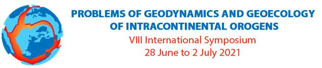
VIII International Symposium «PROBLEMS OF GEODYNAMICS AND GEOECOLOGY OF INTRACONTINENTAL OROGENS» was held from 28 June to 2 July 2021 within the framework of a Year of Science and Technologies in Russia on the basis of Research Station of RAS (Bishkek city, Kyrgyz Republic).
The Organizing Committee thanks all participants of Symposium!
The Book of Abstracts of the Symposium and presentations of participants is available at the link:
https://cloud.mail.ru/public/HncU/jyRb8WdHC
Video of online sessions:
Opening. Plenary session – 28 June 2021 : https://youtu.be/jUc8ztGnGJg
Section 1 (part 1) – 29 June 2021 : https://youtu.be/5Aa-WHlpaR0
Section 1 (part 2) – 2 July 2021 : https://youtu.be/xGAqjoQR1C4
Section 2 – 29 June 2021 : https://youtu.be/pfKeD4YQkEk
Section 3+6 – 30 June 2021 : https://youtu.be/gX38ecW_cjE
Section 4 – 1 July 2021 : https://youtu.be/k2AoM2S9nwM
Section 5 – 1 July 2021 : https://youtu.be/gkkgegXiRok
The Organizing Committee wishes all colleagues success and a positive mood!
Best regards,
Olga Zabinyakova
Academic Secretary of RS RAS
This e-mail address is being protected from spambots. You need JavaScript enabled to view it
+996 (312) 61-31-40
Last Updated on Thursday, 29 July 2021 10:53
VIII International Symposium
Monday, 12 July 2021 14:29
Dear colleagues!
VIII International Symposium «PROBLEMS OF GEODYNAMICS AND GEOECOLOGY OF INTRACONTINENTAL OROGENS» was held from 28 June to 2 July 2021 within the framework of a Year of Science and Technologies in Russia on the basis of Research Station of RAS (Bishkek city, Kyrgyz Republic).
The Organizing Committee thanks all participants of Symposium!
The contact email address is This e-mail address is being protected from spambots. You need JavaScript enabled to view it .
As it was mentioned earlier, selected papers from the Symposium will be recommended for publication in a foreign edition. IOP Conference Series: Earth and Environmental Science. Personalized invitations, as well as all accompanying information, will be sent to the participants in the near future. Submission of material in the IOP Conference Series implies that you agree to the Publisher's License
(https://publishingsupport.iopscience.iop.org/questions/iop-proceedings-licence/) and familiarized with the rules of registration of materials
(https://publishingsupport.iopscience.iop.org/author-guidelines-for-conference-proceedings/).
Best regards,
This e-mail address is being protected from spambots. You need JavaScript enabled to view it
Last Updated on Monday, 12 July 2021 15:15
News of Group of New Technologies Introduction
Wednesday, 16 June 2021 09:53
RS RAS and IS NAS KR scientific collaboration
The cooperation between the RS RAS and the Institute of Seismology of the National Academy of Sciences of the Kyrgyz Republic (IS NAS KR) continues in the field of seismological research.
The employees of the Institute of Seismology carried out field seismological research in the Issyk-Kul region in accordance with two agreements from January 8th to May 21t, 2021. The Group of New Technologies Introduction has prepared and delivered three sets of RT130-01 seismic stations with STS-2 seismic sensors. The software and methodological documents for conducting research were also handed over. RT130-01 stations and STS-2 seismic sensors were purchased with financial assistance of CRDF (U.S. Civilian Research and Development Foundation) - American Civilian Research and Development Foundation.
Field works involves the installation of RT130-01 type seismic stations, complete with wide-range STS-2 seismic sensors in the studied area and continuous recording for a certain time of microseisms and vibrations from remote earthquakes and industrial explosions. The duration of observations depends on the level of seismic activity at the territory and is set in such a way as to register at least 10 seismic events with good recording quality. One recording point was taken as a reference. The rest of the items are mobile.
Problems arose during the data processing. The level of seismic interference is significantly higher than the level of microseisms during the station installation and the terminal usage, with the help of which the equipment is controlled and monitored. Microseisms are indistinguishable in comparison with these background disturbances. It is necessary to remove noisy beginning and the end in the data record and areas with the operator presence near the sensor for high-quality data processing.
The staffs of GNTI RS RAS also provide IS NAS KR with methodological assistance, operator training and consultations during field work, provision of seismic data processing programs.
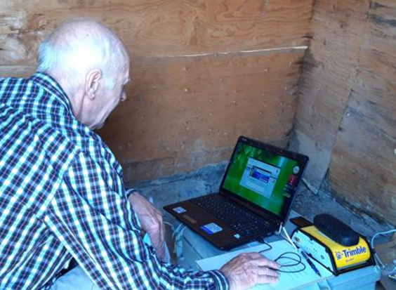
The maintenance of the network of GPS stations continues. You can see below the workplace at the Osh’s station in the picture:
After 7 years of cooperation, our curator Sarah Doelger moved to another UNAVCO division. Jacob Sclar will temporarily perform her duties.
June 11, 2021
Last Updated on Wednesday, 16 June 2021 09:57
XIII International Conference of Young Scientists and Students “Modern Technique and Technologies in Scientific Research”
Friday, 14 May 2021 09:29
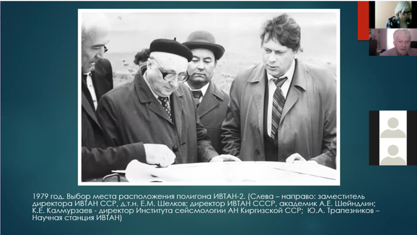
From 28 to 30 April 2021, the XIII International Conference of Young Scientists and Students "MODERN TECHNIQUE AND TECHNOLOGIES IN SCIENTIFIC RESEARCH" was held at the Research Station of RAS in Bishkek city (RS RAS) (online). The opening of the Conference took place on April 28 and was marked by a report of RS RAS Director, Dr Anatoly Rybin. His report was dedicated to the history of the Research Station and memories of its founder and first director - Yuri Trapeznikov.
During three working days of the Conference students and young scientists from Kyrgyzstan, Khazakstan, Uzbekistan, Tajikistan, Russia and Ukraine presented about 50 reports on three thematic directions.
Last Updated on Wednesday, 26 May 2021 11:53
VIII International Symposium
Monday, 17 May 2021 09:42
Dear colleagues!
We would like to remind you of VIII International Symposium «PROBLEMS OF GEODYNAMICS AND GEOECOLOGY OF INTRACONTINENTAL OROGENS» to be held from 28 June to 2 July 2021 within the framework of a Year of Science and Technologies in Russia on the basis of Research Station of RAS (Bishkek city, Kyrgyz Republic).
Symposium format: online
More information on Symposium you can find by the reference below:
Please, take a note, that following numerous applications of participants the Organizing Committee took a decision on prolongation of deadline for application and reports submitting to 25 April, 2021.
Первый циркуляр_VIII Симпозиум НС РАН 2021
Требования к оформлению тезисов
Last Updated on Monday, 17 May 2021 13:18
More Articles...
Page 11 of 27
Projects
Scientific divisions
Science
Photogallery


