


The main results in 2015
In order to construction a comlexe geological and geophysical model of the Tien Shan, the geoelectric cross-sections obtained as a result of solution the direct three-dimensional problem of the Issyk-Kul depression and the 2D inverse problem of the Barskaun profile (southern side of the Issyk-Kul depression) were analyzed. As a result of the interpretation of magnetotelluric data, a structure was identified that is located in the depth interval 0-45 km, spatially confined to the Predterskei fault, and the spatial heterogeneity of this geoelectric structure along the meridional strike was determined.
By comparison the results of the interpretation of magnetotelluric data (2D inversion) and seismotomographic constructions performed by different authors with different databases, the verification of geoelectric models was carried out, and the nature of crustal conductivity was assessed at different spatial-scale levels. Analysis the distribution of the hypocenters of seismic events in the conjunction zone of the Terskey system of uplifts and the Issyk-Kul depression (Barskaun profile) showed a significant concentration of earthquake focus in the zone of high resistivity in the southern mountainous part of the profile. This seismically active zone is spatially confined to the Paleozoic granitoids. On the contrary, in the northern part of the profile, an area of reduced seismic activity was revealed, corresponding to a thick middle-lower crustal conductive zone. This relationship between the distribution of seismicity and the geoelectric characteristics of the cross-section is confirmed by the authors' explanation of the physical nature of the identified conducting structures based on hypotheses of fluidization and partial melt of the earth's crust.
The behavior of variations in the electrical conductivity of the Earth's crust in a broad band of periods has been investigated according to the data of profile magnetotelluric soundings (MTS) at the Kentor geophysical monitoring minitest site. Field experiments confirm the concept of the relationship between the stress-strain state of the environment and the change in apparent resistivity through the redistribution of mineralized solutions between fracture systems.
A new approach to presenting the results of the correlation analysis of magnetotelluric monitoring data in the polar coordinate system is proposed. Regions (clusters) of stable correlation are highlighted on the polar correlation diagrams, which are an integral measure of the relationship between variations of electromagnetic parameters and deformations of the day surface.
The experimental results obtained indicate that the position of the clusters on the correlation polar diagrams is associated with the geoelectric structure of the observation point and corresponds to the orientation of the main tectonic elements in the vicinity of this point. As a result of the analysis of gravitational tidal effects and magnetotelluric parameters, it was found that the nature of the relationship depends on the geoelectric structure of the sounding point and is reflected in the distribution of stable clusters on the polar correlation diagrams. It was revealed that the orientation of the main tectonic faults (near the sounding point) corresponds to the position of the clusters on the correlation polar diagrams. An estimation of the informativeness of additional impedances was carried out, on the basis of it was concluded that this parameter should be used to estimating the tensosensitivity of observation points.
The executed electromagnetic studies revealed the differences in the passing of stress-strain processes in different horizons of the earth's crust. At the same time, on the territory of the Bishkek Geodynamic Proving Ground, the activation of near-surface deformation fields, as a rule, does not lead to earthquakes. While deep deformation processes are realized by earthquakes of various strengths. Taking this fact into account, it can be argued that the difference method for studying variations in the geomagnetic field, which is currently used, may turn out to be ineffective. Moreover, as follows from the above calculations, the closer the receiving stations (magnetovariational stations) are located, the less their sensitivity to deep processes. With an increase in the distance between the receiving stations, the undercompensation of the external field affects.
The main results in 2016
In the context of the construction of a complex geological and geophysical model of the Tien Shan, the geoelectric cross-section along the Tash Bashat profile was analyzed, obtained as a result of solving the 2D inverse problem for the Kentor minitest site. As a result of the interpretation of magnetotelluric data, a structure was revealed that is located in the depth interval of 0-6 km, spatially confined to the Shamsi-Tyunduk fault, and the spatial heterogeneity of this geoelectric structure along the meridional strike was determined. The verification of geoelectric models was realized by comparison the results of the interpretation of magnetotelluric data (2D inversion) and geological constructions performed by different authors, and the nature of crustal electrical conductivity was realized at various spatial-scale levels.
The analysis of the distribution of seismic events hypocenters and the behavior of variations in electromagnetic parameters was realized for the Chon-Kurchak and Ak-Suu stations using the example of a swarm of seismic events that occurred on February 9-16, 2016 near the Kegety electromagnetic monitoring point (20 km from the Chon-Kurchak station).
The behavior of variations in the electrical conductivity of the Earth's crust in a broad band of periods has been investigated according to the data of profile magnetotelluric soundings (MTS) at the Kentor geophysical monitoring minitest site. Field experiments confirm the concept of the relationship between the stress-strain state of the environment and the change in apparent resistivity through the redistribution of mineralized solutions between fracture systems.
A new approach to presenting the results of the analysis of magnetotelluric monitoring data in the polar coordinate system is proposed. Regions (clusters) of stable correlation are highlighted on the polar correlation diagrams, which are an integral measure of the relationship between variations of electromagnetic parameters and deformations of the day surface. The experimental results obtained indicate that the position of the clusters on the correlation polar diagrams is associated with the geoelectric structure of the observation point and corresponds to the orientation of the main tectonic elements in the vicinity of this point. As a result of the analysis of gravitational tidal effects and magnetotelluric parameters, it was found that the nature of the relationship depends on the geoelectric structure of the sounding point and is reflected in the distribution of stable clusters on the polar correlation diagrams. It was revealed that the orientation of the main tectonic faults (near the sounding point) corresponds to the position of the clusters on the correlation polar diagrams. An estimation of the informativeness of additional impedances was carried out, on the basis of it was concluded that this parameter should be used to estimating the tensosensitivity of observation points.
To increase the efficiency of the monitoring system and forecasting as a whole, software was developed to calculate electromagnetic parameters and visualize the results of profile magnetotelluric monitoring. The basis for the development of methodical support for the system of processing and analysis of materials for broad band magnetotelluric monitoring was based on a comprehensive analysis of the time-frequency series of all electromagnetic parameters.
The issues of noise blanking are considered and compared with algorithms for optimal signal processing. Analysis of noise blanking algorithms in comparison with optimal signal processing algorithms showed that blanking algorithms almost always lose in efficiency to optimal processing algorithms. The analysis of interference suppression algorithms based on quadrature compensators leads to the same conclusion.
The database of time series of variations in electromagnetic parameters was supplemented by both new results of monitoring magnetotelluric observations obtained at stationary MT-monitoring stations Ak-Suu and Chon-Kurchak in 2016, and by the results of repeated soundings performed in a broad band at the Kentor minitest site at three regime points of MT-monitoring and 2 sessions of profile magnetotelluric monitoring.
The main results in 2017
As a separate stage on the way of construction a complex geological and geophysical model of the Tien Shan, geoelectric sections were analyzed along the Kentor Central and Kentor East profiles, obtained as a result of solving the 2D inverse problem for the Kentor minitest site. As a result of the interpretation of magnetotelluric data, geoelectric models were built in two profiles and a conductive structure was identified, which is located in the depth interval of 0-6 km, spatially confined to the Shamsi-Tyunduk fault. The spatial heterogeneity of this geoelectric structure along the meridional strike was also determined. Geometric and electrical characteristics of areas with low resistivity in the obtained geoelectric cross-section have been determined. Based on the results of geoelectric studies, the physical characteristics of the Kentor minitest site and the activated fault structures and fractured zones of the basement, both major (Shamsi-Tyunduk fault) and minor, of a lower rank, were supplemented and detailed. Revealed activated faults, assumed under the cover of modern sediments, the so-called hidden fault structures.
The verification of the constructed geoelectric models was carried out by comparison the results of 2D inversion for three MTS profiles, including Kentor West, performed in the Baitik depression, both for studying the geoelectric structure and for conducting profile magnetotelluric monitoring, and geological constructions performed by different authors, and carried out the estimation of the nature of crustal electrical conductivity at various spatial and scale levels.
In order to conduct a thorough analysis of the obtained material for the presence of industrial noise (magnetotelluric time series and estimation of transfer functions based on them), the MT data obtained at the Kentor minitest site was processed according to the remote reference method (with a remote base). The Chon-Kurchak and Ak-Suu magnetotelluric stations were used as a remote base.
The remote reference processing technique in the experiment carried out at the Kentor minitest site in 2014-2015 did not introduce radical changes in the distribution of variations in apparent resistivity and impedance phases. Perhaps this is due to the fact that the level of interference at the sounding point is much lower than at the baseline.
An interactive software tool has been created that provides effective storage and detailed processing of the observed magnetotelluric monitoring data presented in the international EDI format. In the context of an detailed analysis of electromagnetic data, the procedures for calculating the components of the impedance tensor and the phase tensor, depending on the angle of rotation of the coordinate system relative to the initial orientation of the electromagnetic field components at different periods, and constructing polar diagrams of the impedance tensor and phase tensor are realized. The developed software contributes to the optimization and development of the azimuth monitoring technique.
The estimations of the characteristics of the stress-strain state of the geoenvironment were realized on the basis of the analysis of the dynamics of electromagnetic parameters according to the data of electromagnetic monitoring. As the results of electromagnetic observations in 2017 showed, the variations in ρк reflect the changes in the stress-strain state of the geo environment not only before significant seismic events. In the ρк time series, the observed anomalous effects were quite comparable by value with those observed during the preparation of seismic events of a higher class.
In order to further development the methodological support of the system for processing and analyzing materials for broad band magnetotelluric monitoring, experimental and methodological works was realized at the Kentor minitest site, located in the immediate vicinity of the location of the Research Station RAS. In the recorded time series, it is possible to identify characteristic signs of changes in the stress-strain state of the environment, which can be caused by seismic events was demonstrated. Analysis of time series of variations in electromagnetic parameters was carried out in a broad band based on the results of continuous magnetotelluric observations.
The executed electromagnetic studies revealed the differences in the passing of stress-strain processes in different horizons of the earth's crust. At the same time, on the territory of the Bishkek Geodynamic Proving Ground, the activation of near-surface deformation fields, as a rule, does not lead to earthquakes. While deep deformation processes are realized by earthquakes of various strengths. Taking this fact into account, it can be argued that the difference method for studying variations in the geomagnetic field, which is currently used, may turn out to be ineffective. Moreover, as follows from the above calculations, the closer the receiving stations (magnetovariational stations) are located, the less their sensitivity to deep processes. With an increase in the distance between the receiving stations, the undercompensation of the external field affects.
The database of time series of variations in electromagnetic parameters was supplemented by both new results of monitoring magnetotelluric observations obtained at stationary MT-monitoring stations Ak-Suu and Chon-Kurchak, and by the results of repeated soundings performed in a broad band at the Kentor minitest site at three regime points of MT-monitoring and 2 sessions of profile magnetotelluric monitoring for a period from 01.01.17 to 31.12.17.
The main results in 2018
In order to construction a complex geological and geophysical model of the Tien Shan, the geoelectric cross-section along the Tash Bashat profile was analyzed, obtained as a result of solving the 2D inverse problem for the Kentor minitest site. As a result of the interpretation of magnetotelluric data, a structure was revealed that is located in the depth interval of 0-6 km, spatially confined to the Shamsi-Tyunduk fault, and the spatial heterogeneity of this geoelectric structure along the meridional strike was determined.
The verification of geoelectric models was carried out by comparison the results of interpretation of magnetotelluric data (2D inversion) and geological constructions performed by different authors, and the nature of crustal electrical conductivity was estimated at various spatial-scale levels. Analysis of the distribution of hypocenters of seismic events.
The behavior of variations in the electrical conductivity of the Earth's crust in a broad band of periods has been investigated according to the data of profile magnetotelluric soundings (MTS) at the Kentor geophysical monitoring minitest site. Field experiments confirm the concept of the relationship between the stress-strain state of the environment and the change in apparent resistivity through the redistribution of mineralized solutions between fracture systems.
The experimental results obtained indicate that the position of the clusters on the correlation polar diagrams is associated with the geoelectric structure of the observation point and corresponds to the orientation of the main tectonic elements in the vicinity of this point. As a result of the analysis of gravitational tidal effects and magnetotelluric parameters, it was found that the nature of the relationship depends on the geoelectric structure of the sounding point and is reflected in the distribution of stable clusters on the polar correlation diagrams. It was revealed that the orientation of the main tectonic faults (near the sounding point) corresponds to the position of the clusters on the correlation polar diagrams. An estimation of the informativeness of additional impedances was carried out, on the basis of it was concluded that this parameter should be used to estimating the tensosensitivity of observation points.
The executed electromagnetic studies revealed the differences in the passing of stress-strain processes in different horizons of the earth's crust. At the same time, on the territory of the Bishkek Geodynamic Proving Ground, the activation of near-surface deformation fields, as a rule, does not lead to earthquakes. While deep deformation processes are realized by earthquakes of various strengths. Taking this fact into account, it can be argued that the difference method for studying variations in the geomagnetic field, which is currently used, may turn out to be ineffective. Moreover, as follows from the above calculations, the closer the receiving stations (magnetovariational stations) are located, the less their sensitivity to deep processes. With an increase in the distance between the receiving stations, the undercompensation of the external field affects.
Keywords: complex geological and geophysical model, direct three-dimensional model, Tien Shan, nature of electrical conductivity, seismic regime, monitoring, active fault zones, deformation, lunar-daily tides.
The main results in 2019
In the context of the task by creating an complex geological and geophysical model of the deep structure of the Tien Shan lithosphere at various spatial and scale levels, the materials of electromagnetic sounding were collected and a quantitative interpretation of geological and geophysical data in the zone of concentrated deformations of the Northern Tien Shan (the conjunction of the Kyrgyz Range and the Chuy depression) was performed. Two-dimensional geoelectric cross-sections of the lithosphere of the Northern Tien Shan were built along five profiles intersecting the southern site of the Chuya depression on the territory of the Bishkek Geodynamic Proving Ground.
Using the example of five magnetotelluric profiles of the Bishkek Geodynamic Proving Ground, the possibility of using the L-curve in determining the optimal regularization parameters for 2D inversion of these data was analyzed: the optimal regularization parameters were found for the Kara-Balta, Sokuluk, Serafimovka and Tujuk profiles, and geoelectric sections were constructed along these profiles. Also, using the Alamedin profile as an example, it was found that the L-curve can also serve as an indicator of incorrect input data, the reasons for which may be, for example, inaccurate averaging of impedance curves and the construction of their spline interpolants when preparing field data for inversion, or, for example, the need to take into account the influence of near-surface heterogeneities using the "Static Shift" procedure.
A three-component gradient system for registration a seismoacoustic signal has been developed and tested, the using hardware solutions are validated. The system consists of 18 seismic sensors assembled in 6 three-component seismic receivers on three bases. The output signals of the sensors are switched by an external switch to its output, which, through a matching device, transmits them to the input of the computer's sound card, the switch is controlled via the LPT port. The control program on the computer provides configuration of external devices, switching and signal capture. The system can be used to the study of geodynamic processes, the direction finding of seismoacoustic signal sources will make it possible to compare their activation with the activation of an endogenous MT-field source.
Based on the results obtained when testing the three-component gradient system, it was concluded that occurrence a stable relationship between the anisotropy of electrical resistivity and the energy characteristic of the electromagnetic field of endogenous origin.
An estimation of the characteristics of the stress-strain state of the geological environment and the behavior of variations in electromagnetic parameters was carried out in order to identify patterns in their relationship for the seismically active regions of the Tien Shan. Based on the spectral analysis of non-tidal variations of the electromagnetic and gravitational fields, it was found that the spectra of variations in the magnetotelluric field and non-tidal variations gravity are determined mainly by space weather.
For the processing, interpretation and correlation analysis of time series of the electromagnetic field, software was developed and a certificate of state registration of a computer program was obtained (RU 2019618606, 2019).
The seismic regime for the territory of the Bishkek Geodynamic Proving Ground in 2019 compared to 2018 was distinguished by greater stability, the absence of strong earthquakes and a small number of moderate events, with the exception of the southeastern edge of the Proving Ground, where seismic activity is still at the same level, which is reflected in the results of electromagnetic soundings and is confirmed by the data of geomagnetic observations.
The database of time series of variations in electromagnetic parameters was supplemented with new results of monitoring magnetotelluric observations obtained at stationary MT monitoring points Aksu and Chon-Kurchak, with the results of repeated profile soundings performed in a broad band at the Kentor minitest site (2 sessions of profile magnetotelluric monitoring) and at the tensosensitivity regime points of MT-monitoring of the Kochkor depression. The data of azimuthal MT monitoring of electromagnetic parameters are presented in the form of time-frequency series of apparent resistivity, impedance phase, real and imaginary parts of the main and additional impedances, as well as a tipper (Ro, ϕ, ReZxy, ImZxy, ReZxx, ImZxx, W), which allows estimate the variations in the electrical characteristics of the environment in the vicinity of the monitoring point. The validity check of time series of azimuthal MT monitoring is carried out by comparison and analyzing various types of data with each other and in correlation with tidal effects.
The most important research result of the RS RAS in 2019, obtained by the laboratory staff
The theoretical positions of the methodology of separating the magnetotelluric field by the location of the sources have been developed, which makes it possible to single out the component of endogenous origin in the electromagnetic field observed on the day's surface, due to the processes of cracking in the earth's crust.
Using the developed software, this approach was tested on experimental data from magnetotelluric soundings of the Tien Shan. A stable correlation was revealed between the deformation parameters of lunisolar tides and the energy characteristics of the electromagnetic field of endogenous origin, and, firstly, deformations of lunisolar tides occur, and then, with a certain time delay (about 2 hours), the energy of the electromagnetic field of endogenous origin also changes. The hypothesis of a causal relationship between lunisolar tides and the endogenous component of the electromagnetic field has been confirmed.
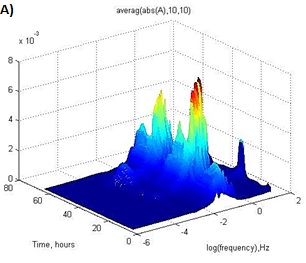
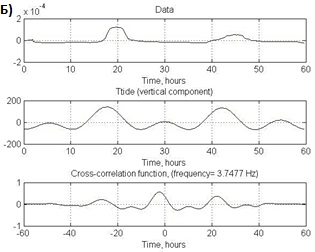
Figure. A) MT-point 901. Calculation of the energy characteristics of the electromagnetic field of endogenous origin. B) Results of comparison the energy characteristics of the electromagnetic field (top graph) and lunisolar tides (middle graph) at a frequency of 3.7477 Hz. Below is the cross-correlation function of the upper and middle curves.
The result was obtained within realized in RS RAS the RFBR project 17-05-00844 "Study of modern geodynamic processes in seismically active regions by the magnetotelluric sounding method (by the example of the Tien Shan)".
Authors: Rybin A.K., Alexandrov P.N., Bataleva E.A., Matiukov V.E., Zabinyakova O.B., Nepeina K.S.


