
The main activity of LGPS is aimed at studying the modern movements of the Earth's crust and related geodynamic processes by methods of land and space geodesy by the example of the Central Asian region. The laboratory is engaged in a comprehensive interpretation of geodetic and seismic data using results from related Earth sciences; assessing the accuracy of used methods of geodetic measurements, improving the methodology for obtaining data, attracting advanced technologies and developing new approaches to data analysis.
The Laboratory for studying modern movements of the Earth's crust using space geodesy (LGPS) was founded on February 19, 2001 and is one of the main scientific units in the structure of the Federal State Budget Institution of Science Research Station of the Russian Academy of Sciences in Bishkek city (RS RAS).
Initially, the laboratory included specialists involved in studying the movements of the Earth's crust surface since 1983. Initially, these studies were carried out using traditional ground-based geodetic methods (light-ranging measurements). Based on the results of such work, data were obtained on the relationship of deformation processes with the accumulation of elastic energy and other geophysical parameters in various parts of the Earth's crust.
Since 1992, with the participation of a significant number of Soviet and foreign partners, the Global Positioning System (GPS) method has been intensively introduced by RS RAS. Unlike traditional ground-based linear angular measurements, the GPS method does not require direct visibility between the observed points, does not depend on weather conditions and can be carried out around the clock. At the same time, there are no restrictions on the size of simultaneously covered territories; these may be small areas or entire surface of the Earth.
As a result of space geodesic work, the Central Asian GPS network was developing dynamically. Initially, two observational networks were created simultaneously. The initiators of one of them, which is conventionally called "German", were scientists from the Potsdam Geo-Research Center, the Research Station RAS, the Geotechnical and Geo-Ecological Scientific Center of the Russian Academy of Sciences, and the Institute of Astronomy of the Russian Academy of Sciences. Experts from the Institute of Earth Physics RAS, the Institute of Seismology of the NAS of Kyrgyzstan, the Institute of Seismology and the Institute of Astronomy of the NAS of Uzbekistan, and the geodetic services of these republics took part in the work. The first 40 sites points were located in the territories of four republics: Kyrgyzstan, Kazakhstan, Uzbekistan and Tajikistan. Subsequently, the network was expanded to 90 sites points, covering the bulk of the Tien Shan, Tarim and the northern Pamirs. To date, the points of the "German" GPS network for the most part have not been preserved; individual points on the territory of Kyrgyzstan are subject to measurement.
Another network was created by the joint efforts of scientists from the USA, Russia, Kyrgyzstan, Kazakhstan and was originally called "American". Unlike the German network, this network was intended to cover a smaller territory, but with a denser distribution of observation points. The first 13 sites points were laid and measured in the area of the city of Almaty and the northern coast of Issyk-Kul Lake in 1992. In 1993 number of such points increased up to 86. That year the largest measuring campaign was carried out - observations were carried out simultaneously by 18 field groups. Later, this network was built up and densified almost annually, which geographically covered a significant part of Central Asia (Fig. 1.1).
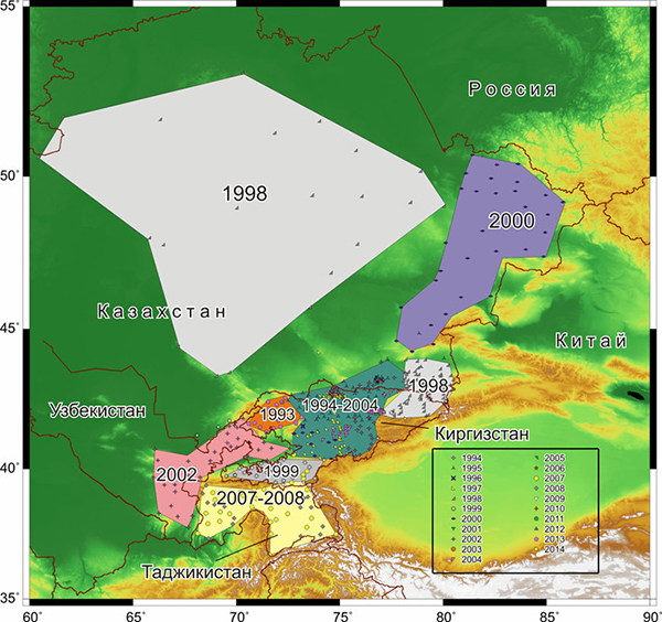
Figure 1.1. GPS observation points and areas of their predominant installation by years on the territory of Central Asia.
Specialists of Research Station RAS developed and manufactured original devices for installing a new type of GPS sites, more adapted for safety and conducting reliable measurements in our conditions. Therefore, since 1994, GPS points have already been measured on new-made sites (Fig. 1.2).
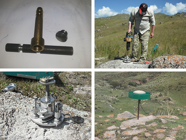
Figure 1.2. Installation of GPS points using the technology of the RS RAS
In 1998, the employees of the Scientific Station made the first bookmark of GPS points and measurements in the central part of Kazakhstan. In 2002, a new network of 35 points was created on the territory of Uzbekistan, which covered the Ferghana Depression and the western spurs of the Tien Shan. Since 2002, based on the exchange, our laboratory has been receiving GPS measurement data from the territory of the Xinjiang Uygur Autonomous Region of China. In 2007-2008, a GPS network was deployed and the first measurements were carried out in Tajikistan with the coverage of the Pamir Mountains and the Tajik Depression. Currently, an area of approximately 1200 × 1800 square km, the total number of points in the Central Asian GPS network for which measurement data are available is about 700 (Fig. 1.3).
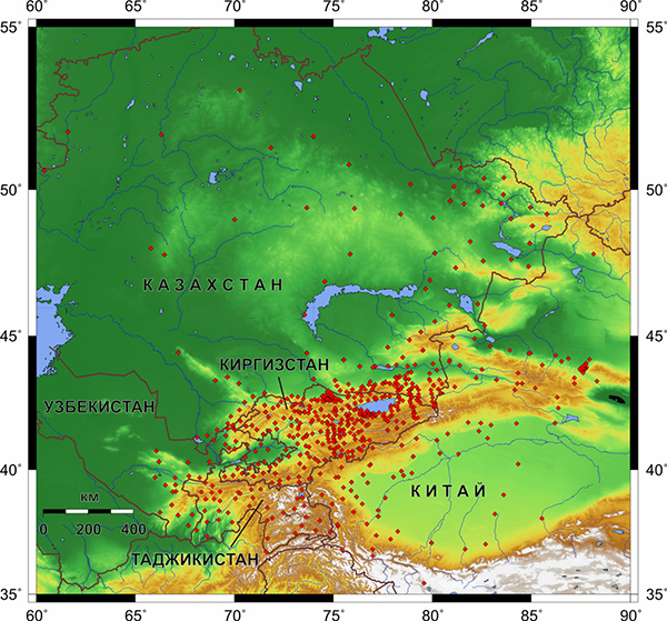
Figure 1.3. Central Asian GPS network is comprised of 685 points on the territory of Kyrgyzstan (357), Kazakhstan (176), Tajikistan (43), Uzbekistan (35) and China (74)
This number includes 15 permanent stations, of which 3 stations are included in the global IGS network. Currently, GPS laboratory staff regularly measure more than 350 points in Kyrgyzstan with a frequency of polling of once every 1-3 years.
In 1997, a local GPS network consisting of 25 points was setablished on the foothills of the Kyrgyz Range, toward the south of Bishkek. Its purpose is to monitor the deformation field in the vicinity of the capital of Kyrgyzstan and improve the GPS measurement technique. Subsequently, the Bishkek local GPS network expanded up to 42 points and became denser. Local network points are located at distances from ~ 2 to ~ 40 km from each other, in average ~ 9 km. Currently, the local GPS network of Bishkek includes 41 points where measurements are taken four times a year in autumn, winter and spring (Fig. 1.4).
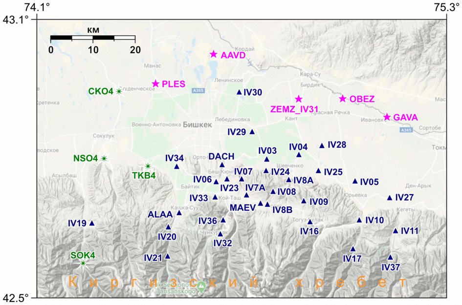
Figure 1.4 - Location of local GPS grid points in Bishkek at the end of 2021: blue triangles - previously installed (32); green stars - installed in 2017 (4); magenta stars - reinstalled in 2021
In 2005-2006 geodesic areas NORUS and ALMALY were installed (Fig. 5) with fundamental benchmarks for comprehensive monitoring of local deformations of the Earth's crust in combination with fan-shaped dipole installations for sensing the formation of an electric field in the far zone. At both sites, linear-angular measurements were taken every 2 weeks, GPS observations were carried out at NORUS site 4 times a year, and continuous GPS measurements are still being carried out at 4 locations on the ALMALY area.
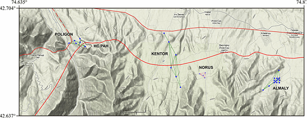
Figure 1.5. The position of the geodetic areas: POLIGON, KENTOR, NORUS and ALMALY, which include the multi-purpose benchmarks for observing deformation processes in local areas of the Earth's crust. Red lines - tracks of active faults
In May 2012, using benchmarks of light-ranging profiles, the POLIGON and KENTOR geodetic areas were established to study deformations in zones of active discontinuous disturbances of the Earth's crust. From this time to the present, weekly linear-angular observations have been carried out at POLIGON, KENTOR and ALMALY areas, and GPS data is collected 4 times a year.
In June 2018, within the POLIGON area, the work of 3 stations POL3, POLY and POL7 was organized in a permanent mode (Fig. 1.6).
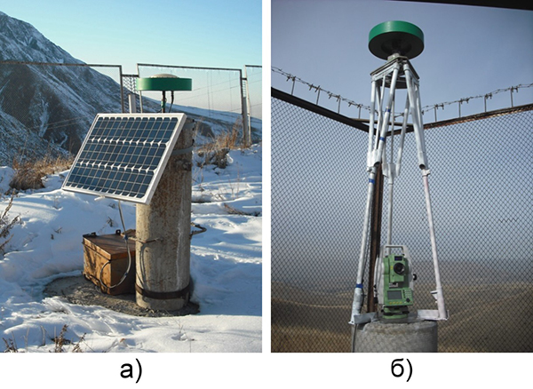
Figure 1.6. a) New POL7 site for continuous GPS observations. b) Equipment of the permanent station POL3 with the possibility of simultaneous GPS and linear-angular measurements.