Magnetotelluric soundings in continental collision zones of Tien Shan and Pamir,
Central Asia
O. Ritter*, A. Rybin**, G. Munoz*, V. Batalev**, T. Krings*, X. Chen*
* Helmholtz Centre Potsdam, GFZ German Research Centre for Geosciences
** Research Station of the Russian Academy of Sciences in Bishkek, Kyrgyzstan
Contacts: This e-mail address is being protected from spambots. You need JavaScript enabled to view it
GP41A-0778
The presentation considers magnetotelluric data obtained within the frameworks of the multidisciplinary program of studying Tien Shan – Pamir region (TIPAGE). The dynamics of orogenic belts of Tien Shan and Pamir is determined by collision of continental plates of India and Eurasia. Geophysical research help us to get the image of the deepest and the most active zone of intracontinental subduction on the Earth (subsidence to the north of Hindukush and subsidence to the south of Pamir) and to find out about structural distribution of this severest deformation on the shortest distance presented in Indo-Asian collision zone.
 |
|
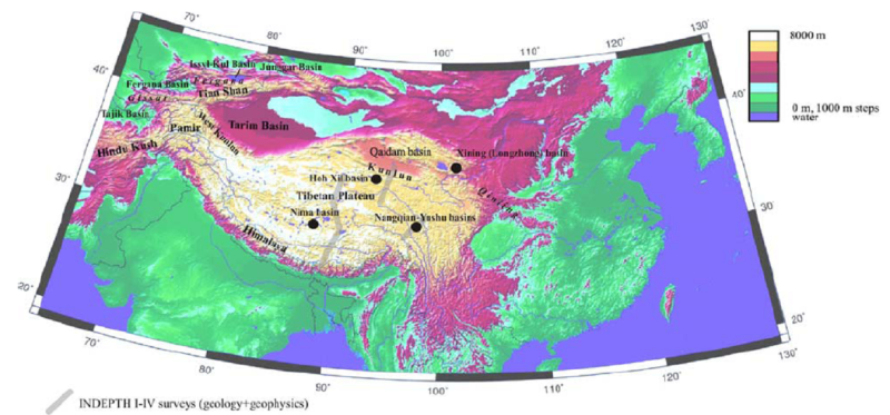
Fig. 1. Tien Shan – Pamir mountain system (“Pamir”) as a northwest corner of Indo-Asian collision zone and Pamir-Tibet plateau. Note that the shortening in north-south direction in Pamir – Western Tien Shan region absorbs less that 50% of shortening length in the east. Depressions are the regions which are almost not subject to intracontinental shortening. The italisized names show the orogenic belts of Paleozoic and Mesozoic ages reactivated by the growth of plateau. |
 |
|
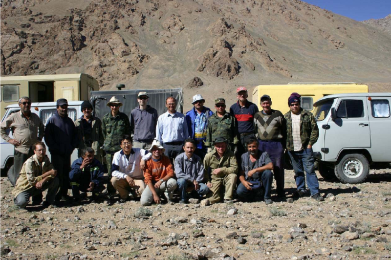
Fig. 2. The international MT team (Kyrgyzstan, Russia, Tajikistan, Germany). The Research Station RAS has provided the major part of field logistics including transportation. Tajik members of the team were local people from Murgab. MT equipment was provided by the Potsdam Geophysical Equipment Pool. |
 |
|
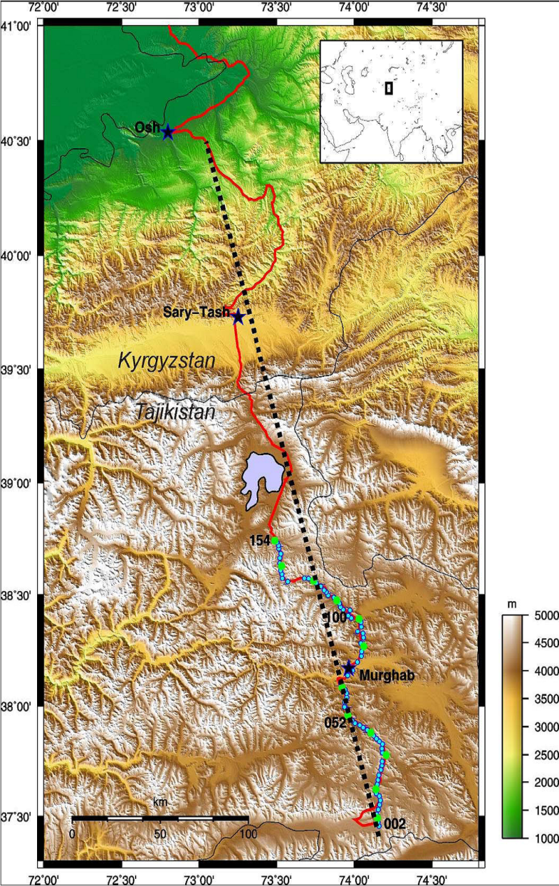
Fig. 3. МТ data were recorded in summer 2008 at 80 stations (12 combined broadband (BB)/long-period (LMT) stations and 68 broadband stations) in Pamir mountain ranges in Tajikistan with a distance of about 2 km between BB stations and 14 km between BB/LMT stations. These stations form the southern segment (156 km long) of the 430-km profile which goes from Osh in Kyrgyzstan through Sary-Tash, Kyrgyz-Tajik border, Karakul and Murgab to Zorkul Lake in the southern Tajikistan. |
 |
|
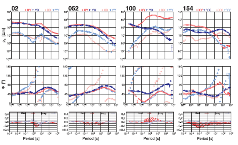
Fig. 4. Examples of apparent resistance and phase curves of the four broadband stations in Pamir. The curves were obtained after a three-day registration and processing in the field. The changing form of the curves points to significant changes in deep conductive structure. The distance between sites is about 50 km. For location of stations see Fig.3. |
 |
|
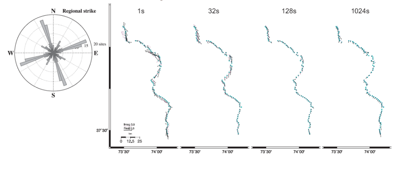
Fig. 5. On the left: Analysis of regional spread (Becken&Burkhard) of all stations in the interval of periods 1-1000s has determined the azimuth of geoelectric spread -17°. |
 |
|
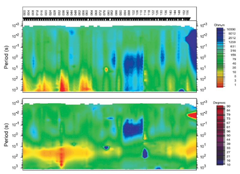
Fig. 6. Pseudo-cross-sections of apparent resistance and phases. TE and TM modes were determined according to the results of tensor decomposition presented in fig.5. |
Acknowledgements:
We are indebted to the following colleagues:
Doctor V.E.Minayev, Institute of Geology, Academy of Sciences of Tajikistan, Dushanbe.
Central-Asian Institute of Applied Geosciences, Bishkek.
G.G.Schelochkov and MT field team: IGRC, Research Station RAS in Bishkek.
Doctor S.K.Negmatullaev: PMP International / Seismological Monitoring Network in Tajikistan, Dushanbe.
Prof. L. Ratschbacher: University of Freiberg, Germany and all other German colleagues who took part in this project.
We express our gratitude to GFZ German Research Centre for Geosciences for significant financial support.
Seismic and magnetotelluric equipment was provided by the Potsdam Geophysical Equipment Pool.
