
In 2017, the staff of GPS laboratory has fulfilled the planned scope of field geodetic observations except for some cases when weather conditions or other objective conditions made it impossible to conduct measurements.
From May to August 2017, we conducted 2 campaigns to measure regional sites at the territory of Kyrgyzstan (fig.1). The regional GPS campaigns involved four field teams including the operator and the driver of ZIL-131 truck. During one month, each team can measure up to 14-15 sites (36 hours for one site). The trucks have travelled 1466-2836 km, ~ 1860 on average.
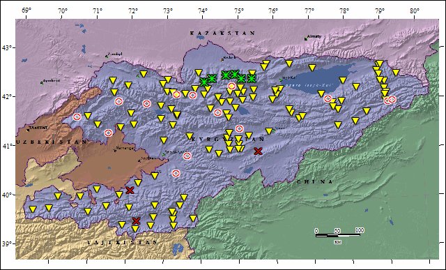
Figure 1 – Regional sites served in 2017. Yellow triangles – installed previously and measured in 2017 (112); green stars – new sites (6); red circles – not measured GPS sites due to bad roads and bridges, bad weather conditions etc. (14); red crosses – sites and marks destroyed by vandals (3).
Since 1997, GPS laboratory staff has been conducting GPS measurements at the sites of Bishkek local network several times a year. These observations are aimed at studying modern movements of the Earth’s crust in the junction zone of Kyrgyz Range and Chui Depression (fig.2). Since 2012, the local GPS network surveying campaign involves 36 sites of local network and 10 fundamental sites of geodetic grounds POLIGON and KENTOR.
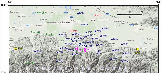
Figure 2 – sites of local GPS network: blue triangles – previously installed sites (32); green stars – sites installed in 2017 (4); red crosses – sites destroyed in 2016-2017 (2); yellow squares – sites transferred to the regional category in 2017. Fundamental posts: lilac diamonds - POLIGON (IP*, 6); lilac circles - KENTOR (IK*, 4).
In 2017, we have conducted 4 full circles of 36-hour measurements at each previously installed site of local network. New sites were measured one time. We have also carried out 10 local campaigns up to 13 days long involving 3-4 teams (fig.3). Next year, to provide a more informative coverage of researched area, we plan to continue reconfiguring the Bishkek local GPS network.
.jpg)
Figure 3 – Measurement of IV21 site of Bishkek local GPS network in December 2017.
Since 2012 to present, we conduct linear-angular measurements of deformation mode at POLIGON, KENTOR and ALMALY geodetic grounds (fig.4) every week. The grounds are 6-14 km away from each other along the line of Shamsi active fault. Each ground is equipped with fundamental benchmarks dispersed at distances from 150 m to 2.5 km. The purpose of these works is to observe the level, character and mode of deformations near active faults.
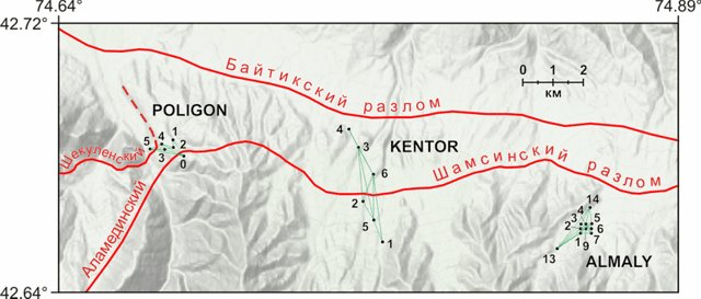
Figure 4 – Geodetic grounds of Bishkek test site, red lines – active faults. The basic lines for linear-angular measurements are highlighted in green. Points and numbers show fundamental benchmarks and their numbers.
In 2017, we conducted from 31 to 36 cycles of measurements at these grounds. At every ground, the measurements were conducted with fixation of slant distance for the baseline, vertical angle and horizontal angle between 2 lines with one common benchmark. Within one cycle, each line was measured in two directions with difference from 5-10 minutes (with 2 operating tachymeters) to 2-3 hours (with 1 operating tachymeter). As a result of unidirectional measurement of baseline in tachymeter memory (depending on its type), on average 5 records with automatic averaging of 10 readings, or 20 records with single measurement of parameters were obtained.
Last Updated on Tuesday, 20 March 2018 08:40