


In 2011, the Research Station of RAS started research on the possibility of using pseudonoise signals (PNS) in active geoelectric exploration systems.
At the first stage (2011 – 2013), the theoretical prerequisites for the effective use of pseudonoise signals (PNS) in geoelectric exploration equipment were analyzed in relation to the tasks of electromagnetic monitoring of the stress-strain state of the earth's crust. During this time, a set of works was carried out on mathematical modeling of the operation of geo-electric exploration equipment using PNS. The simulation was carried out using a specially developed program, which later served as a prototype program for processing registration data of a geoelectric-measuring complex with pseudonoise probing signals. To confirm the theoretical assumptions, the first experimental sample of an electrical survey measuring system with pseudonoise signals (EMS PNS) (Fig. 1). To conduct laboratory and field tests of a mock-up sample of EMS PNS, special software was developed consisting of two programs: the EMS PNS signal registration program (BBSRegistrator) and the program for viewing and primary processing of EMS PNS signals (BBSViewer).
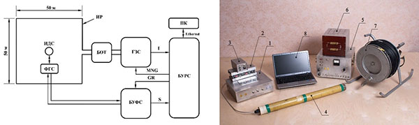
Fig. 1 Structural and functional Diagram and appearance of an electrical survey-measuring complex with pseudonoise signals:
ИР – induction probing frame (7), ИДС – induction signal sensor (4); БУРС – signal control and registration unit (1); БУФС – signal amplification and filtering un (2); ГЗС – probing signal generator (5); БОТ – current limiting unit (6); ФГС – calibration signal generator (3); ПК – personal field computer (Notebook, 8)
The results obtained by mathematical modeling of the equipment showed that the use of pseudonoise signals repeatedly(by 100 times or more) improves the signal/(noise plus interference) ratio at the output of the measuring system with PNS in comparison with traditional methods of sounding the earth's crust, using deterministic probing signals in the form of sequences of rectangular current pulses with a constant duration and pauses between them. The first tests of the experimental sample of EMS PNS manufactured in 2012-2013 in the field mainly confirmed the results of mathematical modeling, but further more thorough research revealed the features of the use of PNS in geo-electric exploration equipment. After correlation processing of registered field signals, so-called "structural interference" was detected in the form of pulse signals of very small amplitude (3 – 5 orders of magnitude less than the maximum value obtained after correlation processing and accumulation of the field formation signal) located along the entire field formation curve (Fig. 2).
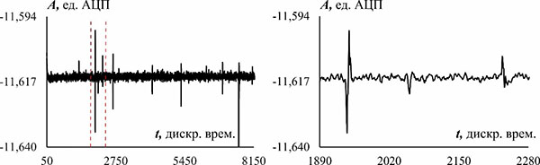
Fig. 2 Example of "structural interference" on a section of the field formation curve
These signals get their name because their appearance is related to the structure and type of noise - like bipolar m-sequences of rectangular pulses used for probing. Despite its small size, "structural interference" can become a limitation when registering and processing weak signals of field formation observed on the earth's surface from objects (layers) located at great depths.
Further research and development on the topic was aimed at identifying the alleged causes of "structural interference" and studying their properties in order to find ways to reduce their impact on the results of signal processing. In 2014 – 2016, such studies were conducted on mathematical models and using physical modeling on a special signal simulator. To study the nature of the detected interference and ways to deal with it, it was necessary to review the structure and capabilities of the previously developed mathematical model of an electrical survey system with pseudonoise signals. As a result, a new program BBSViewerM was developed for mathematical modeling of the operation of the EMS PNS measuring complex. The improved program was intended to continue the study of the possibility and features of using pseudonoise sounding signals in systems of active electrical exploration of the earth's crust in comparison with typical systems that use deterministic bipolar sequences of current pulses with a constant duration for sounding. In the new program, mathematical models of electrical exploration systems with pseudonoise and deterministic probing pulse sequences were implemented, and it was possible to fine-tune model parameters such as: the type and characteristics of probing pulse sequences; parameters of external noise and interference; the type and parameters of the pulse and transient characteristics of the probed medium, etc. In the process of developing the program, mathematical models of "structural interference" were created, the action of which was well coordinated with the observed effects in the correlation processing of real signals in the measuring complex EMS PNS.
As a result, three causes of "structural interference" were identified:
1) Non-linearity of the transmission characteristic of the measuring path, including the object of study-the earth's crust;
2) Pulse interference from the operation of digital circuits of the measuring complex, penetrating through parasitic circuits into the measuring path;
3) Discreteness of the received registration data.
Among the three above-mentioned reasons for the appearance of "structural interference", the discreteness of the registration data makes the least contribution, and the "structural interference" caused by this reason can be significantly reduced by increasing the bit rate of the used analog-to-digital converters (ADC). With signals from the power sensing unit and digital circuits of the measuring complex that fit into the measuring channel, there are also protection methods (maximum separation in space of the power part of the sensing unit and the receiving and recording measuring channel, use of galvanic and optic isolation communication lines for transmitting control signals). The influence of non-linearity of the measuring and sounding parts of the equipment on the level of "structural interference" can also be reduced by using an electronic element base for its implementation, which has a minimum non-linearity of transmission characteristics. But it is not possible to influence the nonlinear nature of the object of research (the earth's crust).
In 2015, a small-sized, thermally stable induction sensor was developed for measuring the flow of magnetic induction, which has a high sensitivity in the frequency range from 0.1 Hz to 80 kHz (Fig. 3).
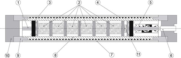
Fig. 3 Design of the induction sensor:
1-ferromagnetic core, 2 – sections of the measuring coil, 3-rubber seal, 4 – calibration coil, 5-pre-amplifier, 6 – connector, 7-external housing, 8-internal housing (screen), 9-locking cylinder, 10-plug, 11-additional non-inductive coil
The technical result of the development is a significant increase in the integration constant while maintaining high temperature stability of the sensor conversion coefficient. A mock-up sample of the sensor was made, which was included in the manufactured measuring complex EMS PNS. The developed sensor can be used in any geoelectric exploration equipment based on the measurement of artificial and natural electromagnetic fields. The completed development is protected by Russian patent No. 168302 dated 30.01.2017 on the utility model "Broadband thermostable magnetic field induction meter".
In 2017, a second experimental sample of the measuring system with improved technical characteristics was produced (Fig. 4).
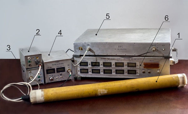
Fig. 4 External view of the measuring channel of the new model sample of EMS PNS:
1-induction signal sensor (ISS); 2-calibration signal generator (CSG); 3 - power supply of the induction signal sensor( PSISS); 4-signal filtering unit (SFU); 5-control and registration unit (CARU); 6-power supply unit CARU (PSCARU)
The control and signal recording unit (CARU ) has been almost completely reworked, and other circuit solutions have also been revised to improve the technical parameters of the measuring complex. The CARU is operated under the control of the EMS PNS signal registration program-BBSRegistrator. The main purpose of the program is to manage the operating modes of the CARU and ensure the registration and storage of digitized data in the memory of the microcontroller with further transfer to an external computer for subsequent processing. Changes in the operating modes and logical structure of the control signals of the new CARU required the development of a new signal registration program. The changes also affected the program for processing registered data of the EMS PNS. The main task of the program is to obtain the field formation curve by directly calculating the cross-correlation function (CCF) between the response of the medium registered on the receiving side to the probing pulse pseudonoise sequences (M-sequence) and the probing single M-sequence. It was decided to combine the program for processing registered data and the program for mathematical modeling in order to obtain an opportunity to quickly compare the results of laboratory and field experiments with the results of mathematical modeling that are closest to them. The new program is called " program for mathematical modeling and data processing of EMS PNS” - BBS_ViewerM_NR.
The results of a laboratory experiment to measure the signal-to-noise ratio of AС/AП (Fig. 5) for two model samples of EMS PNS showed an increased 22 dB (12.6 times) the signal-to-noise ratio measured for the new EMS PNS layout compared to the previously manufactured one.
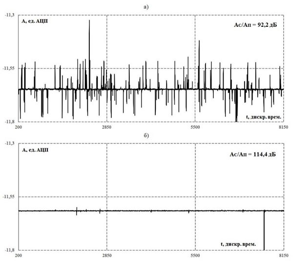
Fig. 5 Fragments of the output signal after correlation processing (graphs of the accumulated CCF, scale on the vertical axis 1:130000): a) for the previously manufactured EMS PNS layout; b) for the new EMS PNS layout
As a result of mathematical simulation of nonlinear transfer characteristics of the crust and instrumentation, as applied to created in RS RAS a new electrical measuring complex pseudonoise signals (EMS PNS) obtained a linear relationship between the amplitude of the so-called "structural noise" that appears at the output of the measuring complex correlation processing of the registered signals and the harmonic distortion signals in the measurement system includes a model of the earth's crust and instrumentation. Therefore, the idea along with the presence of negative effects of "structural interference" (reducing the dynamic range of recorded signals) to use their positive properties, namely, measuring the level of the noise to estimate the non-linearity of the object of study (the transmission characteristics of the earth's crust) and apply this characteristic in addition to an apparent electrical resistance of rocks obtained by electromagnetic monitoring of the stress-strain state of the crust. The idea was mathematically modeled. The results of this simulation showed that against the background of large (1%) but stable (fixed) nonlinear signal distortions in the hardware part of the measuring path, it is possible to control very small variations (0.001%) of nonlinear signal distortions in the earth's crust. This fact requires confirmation on the equipment using physical modeling of non-linearities and in real field conditions of registration of signals of field formation. This work is planned to continue in the future.
In 2018, work on the development and production of an experimental sample of the measuring complex was suspended due to the opportunity to purchase and use modern technologies (new element base: high-speed multi-bit ADC modules, programmable logic modules based on programmable logic chips) that reduce the development and production time of the equipment by an order of magnitude.
In 2018, improvements were made to the equipment of the EMS PNS measuring complex, aimed at improving its technical and operational characteristics. Changes were made to the induction sensor, control unit and signal registration. As a result of updating the control unit and signal registration, a significant reworking of the program code of the signal registration program-BBSRegistrator was required. In 2018, the certificate of the Russian Federation on state registration of the computer program No. 2018614565 was received for this program.
At the end of 2018, it was possible to perform laboratory and field tests of partially converted equipment of the measuring complex. A series of sessions was performed to register signals of field formation at three points on the surface of the earth's crust that differ in Geology. According to the registration data for the selected points on the surface of the earth's crust, the dependence of the apparent electrical resistivity of rocks on the time of formation of the field ρτ(t) is constructed (Fig. 6). Significant differences in the obtained dependences of ρτ(t) for different points on the earth's surface are revealed, indicating a difference in the electrical structure of the earth's crust at the measurement points, which allows using ρτ(t) as the main controlled parameter when conducting electromagnetic monitoring of the earth's crust using a new measuring complex.
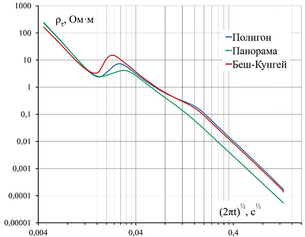
Fig. 6 Resulting graphs of apparent resistivity curves for three points of the earth's surface with different Geology: "Polygon", "Panorama" and " Besh Kungei”
In 2018, laboratory and field experiments with a mock-up sample of the EMS PNS measuring complex to determine controlled parameters for conducting electromagnetic monitoring of the earth's crust required adding new features to the data processing program for model, laboratory and field experiments - BBS_ViewerM_NR. For rapid data processing and analysis, the program added the ability to calculate the apparent resistivity curve of the earth's crust. In 2018, the certificate of the Russian Federation on state registration of the computer program No. 2018614566 was received for this program.
In 2019, a new probing signal generator, current limiting unit and a new receiving induction frame were developed and manufactured.
The development of new probing signal generator and current limiting unit allowed increasing the maximum switching power in the induction sensing frame by three orders of magnitude (from 80 W to 90,000 W). The development of a method for calculating the technical characteristics and parameters of the receiving induction frame made it possible to produce a new improved frame, the noise resistance of which is reduced by 300 times compared to the sample developed in 2012-2013.
The software part of EMS PNS measuring complex was modified, including correction of the BBS_Registrator signal registration program and the BBS_ViewerM_NR model, laboratory and field experiment data processing program, as well as the development of new versions of these programs (BBS_RegistratorADD, BBS_ViewerM_NR_ADD) designed to work with the new algorithm for synchronous accumulation of recorded data in real time implemented in the BBS_RegistratorADD program.
The implementation of the new data accumulation algorithm allowed increasing the sampling rate by about 4.7 times (from 350 kHz to 1638.4 kHz). The new algorithm can significantly reduce the amount of data received, preserving the duration of registration (and number of accumulations) that allows to increase the efficiency of processing and analyzing the recorded data in the field while maintaining the minimum system requirements field computer.
During 2018 – 2019, a new draft technical documentation was developed for all units of the measuring complex, taking into account the purchased new element base.
According to the developed draft technical documentation, in 2019, one experimental sample of a measuring complex with pseudonoise sounding signals (EMS PNS) (Fig. 7), which has technical characteristics that allow testing a new technology for deep active electrical exploration of the earth's crust in relation to electromagnetic monitoring of its stress-strain state at low energy consumption for sounding (about 300 W).
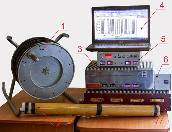
Fig. 7 New layout sample of EMS PNS. The set of EMS PNS includes:
1-probing induction frame (shown in coiled form); 2-induction sensor; 3-probing signal generators; 4-laptop with specially designed software (BBS_RegistratorADD and BBS_ViewerADD); 5-signal control and registration unit; 6-measuring channel calibration unit; 7-current limiting unit; receiving induction frame with pre-amplifier (not shown in the photo)
As a result of modern element base and new technologies use in the development of equipment, the technical and operational characteristics of the measuring complex have been significantly increased. Increased the dynamic range of registered signals from 90 to 110 dB. The frequency range of received signals was expanded from 1 Hz to 0.25 Hz in the low frequency region and from 20 kHz to 130 kHz in the high frequency region, which increased the capabilities of the equipment for monitoring dynamic processes occurring both at small and large depths of the earth's crust. The functional and operational capabilities of the created equipment have been expanded and improved. The number of units in the measuring complex has been reduced, and the power consumed by the EMS PNS measuring channel from batteries has been reduced by a factor of ten.
In 2019, field tests were conducted with a manufactured experimental sample of EMS PNS at the test point "Polygon" closest to the RS RAS and a comparison was made with the results obtained at this point in 2018. Despite the not very good interference situation at the experimental point, the effect of increasing the signal - to-noise ratio by 16.5 times on the new fully modified experimental complex compared to the data obtained at the end of 2018 was obtained.
A series of field experiments with a new model sample of EMS PNS was conducted to test a new technology for active electrical exploration of the earth's crust using pseudonoise probing signals in relation to electromagnetic monitoring of its stress-strain state.
Experiments have shown that the RMS (root mean square) noise level on the field formation curve exceeds the RMS noise level of the measuring channel by 4.75 times. Against the background of interference and noise, the field formation curve is visually clearly distinguished up to long times (large depths), which will allow further applying algorithms for approximating this curve to improve the quality of the resulting curves of the apparent resistivity of the earth's crust.


